***** Update 11:40 p.m. *****
The prior tornado watch for southeast Kansas has been replaced with a severe thunderstorm watch for southeast Kansas and northeast Oklahoma through 7 a.m. Tuesday.
KANSAS COUNTIES INCLUDED ARE

ALLEN                BOURBON             BUTLER
CHAUTAUQUA           CHEROKEE            COWLEY
CRAWFORD             ELK                 GREENWOOD
LABETTE              MONTGOMERY          NEOSHO
SUMNER               WILSON              WOODSON
OKLAHOMA COUNTIES INCLUDED ARE

ALFALFA              BLAINE              CRAIG
GARFIELD             GRANT               KAY
KINGFISHER           LOGAN               MAJOR
NOBLE                NOWATA              OSAGE
OTTAWA               PAWNEE              PAYNE
WASHINGTON
***** Update 8 p.m. *****
Severe storms are not expected to move into southeast Kansas until after 10 p.m. A tornado watch is in effect for the following counties in Kansas through 1 a.m. Tuesaday:
IN SOUTH CENTRAL KANSAS

BUTLER                COWLEY                HARPER
HARVEY                SEDGWICK              SUMNER

IN SOUTHEAST KANSAS

CHAUTAUQUA            ELK                   GREENWOOD
MONTGOMERY            WILSON                WOODSON

THIS INCLUDES THE CITIES OF ANDOVER, ANTHONY, ARKANSAS CITY,
ATTICA, AUGUSTA, BEL AIRE, CEDAR VALE, COFFEYVILLE,
COTTONWOOD FALLS, DERBY, EL DORADO, EUREKA, FREDONIA, GRENOLA,
HARPER, HAYSVILLE, HOWARD, INDEPENDENCE, LONGTON, MADISON,
MOLINE, MULVANE, NEODESHA, NEWTON, PARK CITY, ROSE HILL, SEDAN,
STRONG CITY, VALLEY CENTER, WELLINGTON, WINFIELD,
AND YATES CENTER.
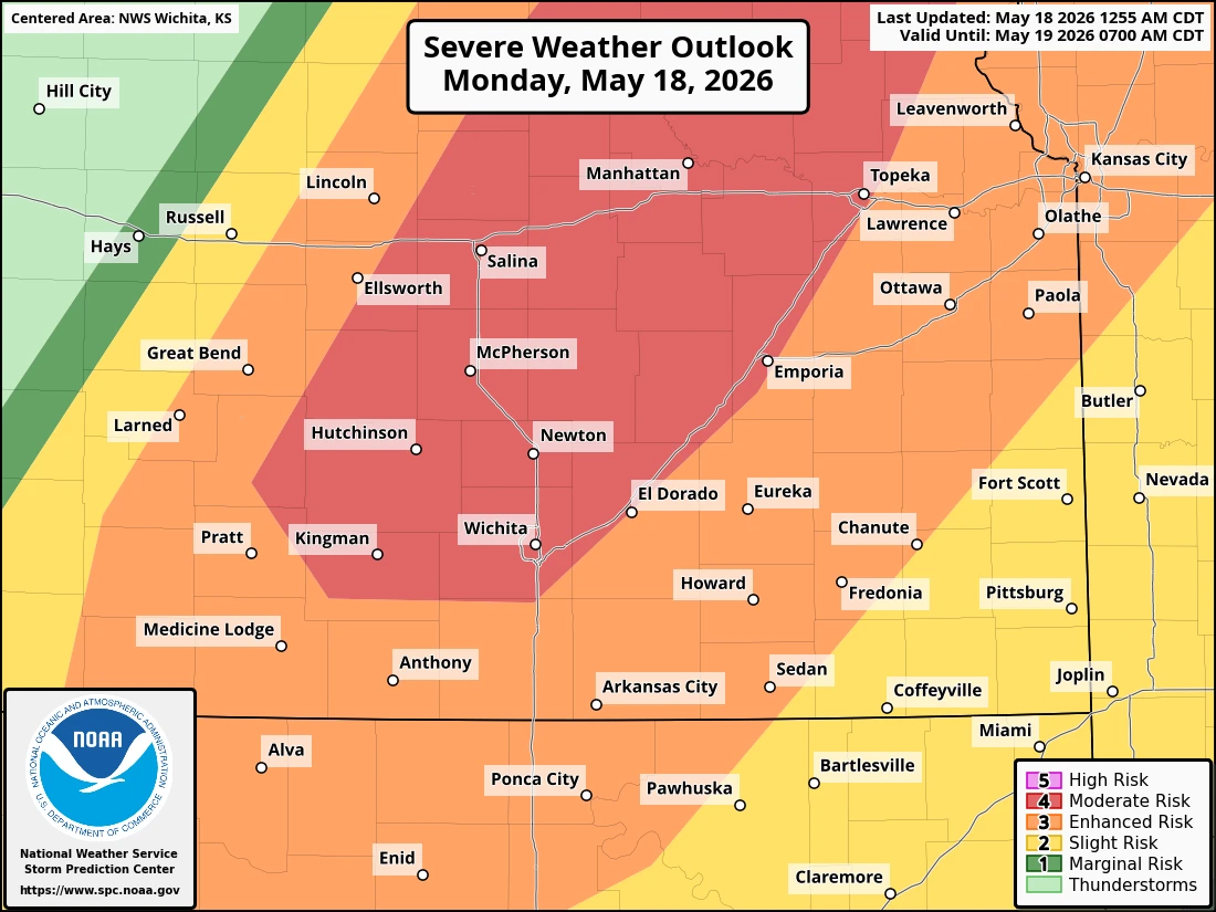
***** Original Story *****
Severe weather is possible tonight across the four-state area.
The best chance for severe weather will be northeast of Wichita towards Topeka, although southeast Kansas and northeast Oklahoma will see a “slight” to “moderate” risk of severe weather, up to a level 3 out of 5.
Hazards include hail up to 2 inches, damaging winds and a few tornadoes.
Storms are expected to initiate along a cold front over central Kansas this afternoon. The storms will then spread slowly southward through the remainder of the night across the four-state area. Storms will impact southeast Kansas generally between 10 p.m. and 3 a.m.
Storms are expected to eventually congeal into a line, with damaging winds and heavy rain becoming the main risk. KGGF will provide severe weather coverage tonight if needed.